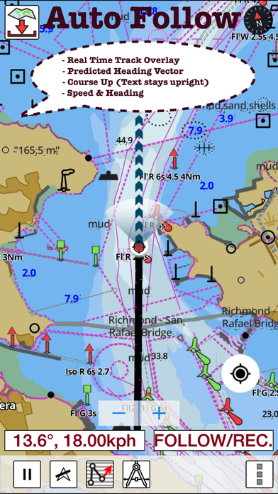
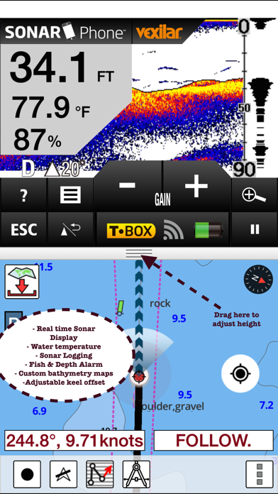
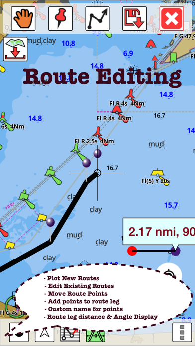
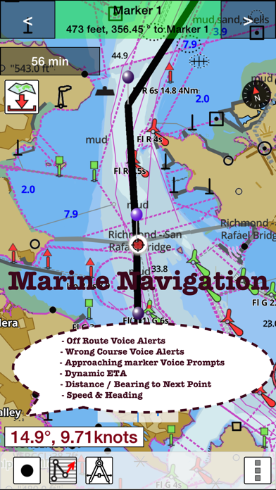
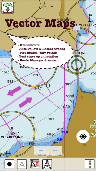
This App offers offline nautical charts, lake & river navigation maps for fishing, kayaking, boating, yachting & sailing covering Australia and New Zealand. Marine navigation coverage includes marine vector charts, freshwater lake maps, and inland river maps (HD/1ft/3ft bathymetry included where available). First marine GPS app to have route assistance with Voice Prompts for marine navigation. You can create new boating routes or import existing GPX/KML routes. It supports Nautical Charts course up orientation. Includes Tide & Currents prediction. ►FEATURES √ Download Beautiful & detailed Hardware/GPU accelerated vector charts (text stays upright on rotation) √ Query details of Maritime object (Buoy, Lights, Obstruction etc). √ Custom depth(Ft/Fathom/Meter) & distance units (km/mi/NM) √ Custom Shallow Depth. √ Record tracks, Autofollow with real-time track overlay & predicted path vector. √ Voice Prompts for marine navigation (requires GPS ) √ 1ft / 3ft depth contour maps for anglers for selected lake maps. Useful for fishing/trolling(freshwater/saltwater). √ Supports GPX/KML for boating route editing/import. √ Tide & Currents. √ Seamless chart quilting. Map details from Coastal, Approaches,Harbour, Inland Encs(rivers), and general ENC (Electronic Marine Charts) are automatically mapped to correct zoomlevel √ Enter / import Waypoints. ► MAPS Get all the details that you find in your chartplotters! Please check website for latest new maps. Includes unlimited updates for 1 year. Australia & New Zealand ►Split Screen Sonar Display √Live Sonar Image & Temperature √Fish & Depth Alarms √Fish Symbols √Adjust temperature and depth units and offsets ►ROUTE MANAGEMENT / TRIP PLANNING √ Create New/Edit Routes √ Reverse Routes √ Enter,Move,Add,Delete,Rename Waypoints √ Import GPX, KML & KMZ files √ Plot/Edit Routes √ Share/Export Routes,Tracks&Markers ►GPS FEATURES √ Auto Follow * Real Time Track Overlay * Predicted Path Vector * Course Up(Text stays upright) * Speed & Heading √ Route Assistance With Voice Prompts * Prompts when approaching a boating route marker * Continous distance & ETA updates * Alerts when sailing/boating off route * Alerts when boating in wrong direction √ Record Tracks ►TIDE & CURRENTS * For US,Canada,UK,Germany&New Zealand * High/Low Tides * Tidal Current Prediction * Active Current Stations ► Available Folios √Arafura Sea √Australian Antarctic Territory √Bass Strait √Bismarck Sea √Coral Sea √Great Barrier Reef √Gulf of Carpentaria √Indian Ocean √Indonesia / Papua New Guinea √New South Wales √Northern Territory √Papua New Guinea (incl. North East Coast) √Port Phillip √Queensland(Great Barrier Reef & Gulf of Carpentaria) √Solomon Sea √South Australia (Gulf St Vincent & Spencer Gulf) √South Pacific Ocean √Tasmania √Tasman Sea √Timor Sea √Victoria √Western Australia ► SHARING * Share tracks/routes/markers on Facebook & Twitter * Export tracks/routes/markers as compressed GPX files. Battery disclaimer: "Continued use of GPS running in the background can dramatically decrease battery life."